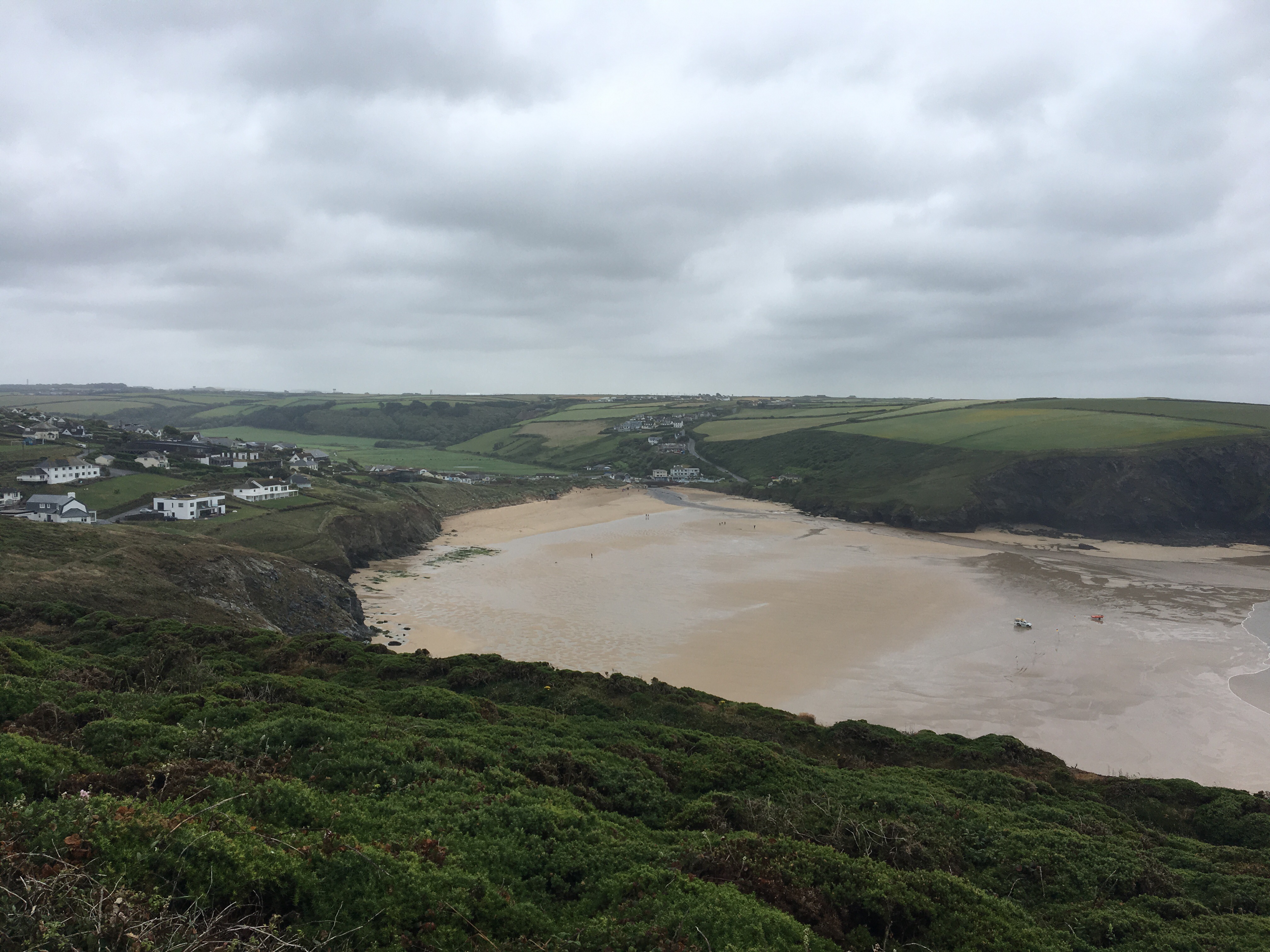
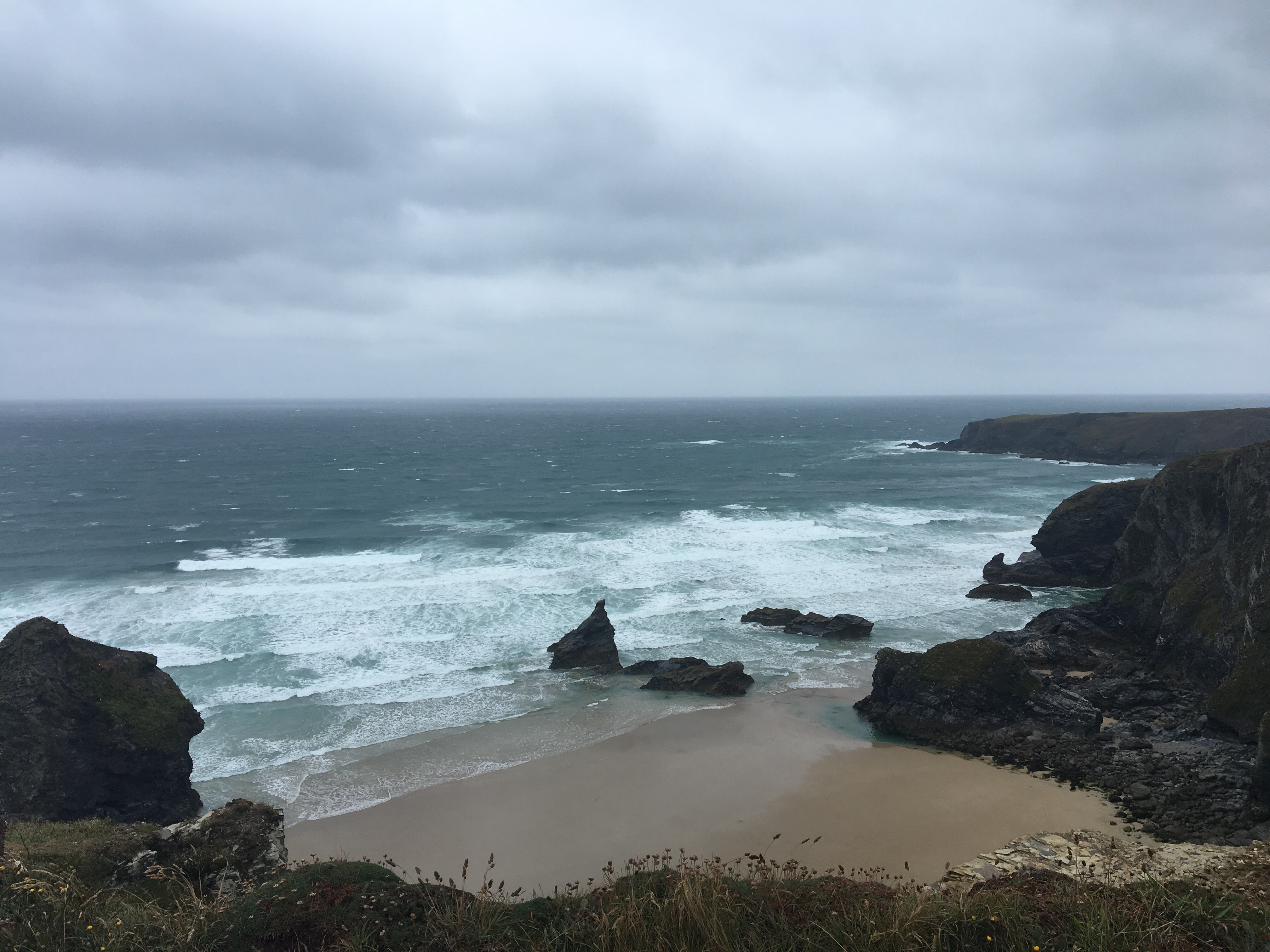
The weather did not improve overnight so I set off in wet and windy conditions, expecting it to get gradually worse until lunchtime at least. I left Wadebridge and followed the Camel Trail, an old railway line along the river Camel for 5 miles towards Padstow.  The walk was mostly sheltered from the wind but by the time I reached Padstow harbour I was once again saturated.After a quick route check I decided to take a B road short cut to Harlyn Bay but quickly realised my life was at risk so had to escape across fields before reaching the safety of quieter lanes. At Harlyn Bay I stopped in the Beach Store to dry off a little and was treated to a free coffee by Helen, who also gave me a detailed local OS map and discussed possible routes to Mawgan Porth. What a star!I chose country lanes to Porthcothan then reassessed and decided to brave the clifftop winds for the remaining 5 miles. It had stopped raining by then but I almost got blown off my feet a couple times. The reward was some fine views.
 I had made good time and crossed the beach at Mawgan Porth in good spirits before climbing the last mile or so up to Trevarrian where the campsite is quite exposed and still extremely windy.
Month: June 2017
JOGLE Day 58 29/06/17 Boscastle – Wadebridge 20 miles
Incessant overnight rain made for a soggy and late start as I mulled over possible routes and helped to make sure Betty wasn’t bogged down at the camp site. I took roads through Boscastle then decided to head for the coastal path at Tintagel – as much out of curiosity to see what it’s really like. As I climbed up onto the clifftop it became apparent how windy it was and only a few die hard tourists at the castle. I followed the SWCP along the cliff top until it dropped down a steep and often slippy path to Trebarwith Strand. There were some good views but at one point I had to stop and brace myself against the strong gusts.
 A hot coffee was in order at the Strand Cafe and I decided then to go for country lanes rather than back on the cliffs. I would anyway be leaving the coastal path at Port Isaac to get to Wadebridge. A combination of AA roadmap, my printed OS pages and some GPS planning plotted a route which took me along lanes through some little Cornish villages like St Teath, Pendoggett and Amble. The final mile or so was back to the Andy Robinson book route and resulted in some boggy overgrown fields with dilapidated stiles and dodgy footbridges – felt like being back in Staffordshire! Got to the camp site safely and found Cath had made a rallying call which meant loads of messages of support and encouragement – quite overwhelming, but much needed as the mental strain is tough to manage and the weather shows not sign of improvement.
JOGLE Day 57 28/06/17 Bude – Boscastle 18 miles
The rain is back with a vengeance – a drizzly start from just outside Bude along lanes at first and through the town centre before picking up the coastal path for an easy few miles to Widemouth Bay – where I took my only photo of the day. The path went through sand dunes – not really needed – and then a mixture of lane and cliff tops before a steep slippery descent into Millook. As I climbed up the lane back onto the cliffs the rain got heavier and the cloud descended. To be honest I am not the biggest fan of coastal paths, and right now my main objective is Lands End in one piece, done checked my route and decided to avoid some more “dangerous” ups and downs by following country lanes from Dizzard to Crackington Haven – these were pretty steep as well but nowhere near as slippery. I stopped for a coffee and wifi and decided to continue along lanes as the terrain got higher and into the clouds at High Cliff. After missing a couple of paths I ended up on a B road and after less than 5 minutes Cath came past in Betty on her way to the campsite. I took a slightly longer route but got there thoroughly soaked. The rain just continued all night so I am reassessing route options to get to Wadebridge and more concerned about whether Betty will manage to get out of this field which is now completely saturated!
JOGLE Day 56 27/06/17 Clovelly – Bude 21 miles
Today started comfortably as I followed my short cut route from Clovelly through farmland and lanes to pass through Hartland before rejoining the SWCP. Saw some real Clovelly long horns  and met a lovely couple in Hartland, Lynda and Michael from Birmingham who gave me a donation for PCUK. The coastal path between Hartland and Bude is a seemingly endless rollercoaster of steep climbs and descents – even with my shortcut I still racked up over 4700 feet of ascent to day and never really got more than 400 feet above sea level. The views however were pretty dramatic in places.


At some point I left Devon and entered Cornwall – the final county on my trek  and passed a large “radio” station before eventually some beaches came into view with the occasionally surfer visible
A few more miles of clifftop fields before I left the coast path and headed for the campsite outside Bude – and the rain started. On the bright side another useless stile to add to my collection. Weather forecast not brilliant for the next few days…
JOGLE Day 55 26/06/17 Great Knightacott Farm – Clovelly 19m
The weather guess for today was cloudy so we were surprised to wake up to sunshine. It was pleasantly warm as I left the farm and headed west towards Instow and Bideford and got my first real views of the sea and coast ahead. I then picked up the Tarka trail and followed the old railway line with views across the Torridge to Appledore and the 2 bridges over the river to Bideford.

 I shortcutted the coastal path around the headland and headed west on minor roads to join it finally at Greencliff. I could see Lundy Island across the sea and the white splash of Clovelly tumbling down the distant cliffs.
 My first taste of the SWCP was pretty much what I expected – a few steep ups and downs to cover before arriving at Peppercombe where I decided to go along the shore rather than the cliffs. An hour later after a difficult walk over rocks, boulders, pebbles I had covered another 2 miles to Bucks Mills. Will stick to the cliff path in future!
 I climbed steeply back up to the cliff path and followed it through woods and fields before the last 2 miles along the Hobby Drive to meet Cath at Clovelly. We decided to wild camp on the visitor centre car park and eat tonight in the village.
 Tomorrow the toughest part of the SWCP down to Bude…..
JOGLE Day 54 25/06/17 Simonsbath – Great Knightacott Farm 24 miles
The temptation to sink a few extra beers in the hotel was resisted with the prospect of a long day in store today. More rain overnight and still getting wetter this morning. Fearless I set off on the Two Moors Way to climb back up onto Exmoor, although an easier road option may have been wiser. I had a map misread blip after less than one mile and wasted about 15 minutes choosing the right route, disturbing 2 wild campers in the process! The moor was bleak, windy and wet (not quite Pennine Way but pretty tough). In the mist I managed to disturb a group of bullocks and had to dodge around them fairly briskly. Next I had to navigate with no paths to Exe Head where another group of cows were guarding the way. Almost by chance I stumbled back onto the right track and had to negotiate some slightly boggy terrain to reach Pinkery Pond before turning south to say goodbye to the moor.

By now I was soaked to the skin and needed to make up time and get dry so I chose minor roads and country lanes to get all the way to Barnstaple via Challacombe, Bratton Fleming (watched a bit of village cricket) and a nice viaduct at Chelfham.
By the time I got to Barnstaple the sun had come out and although getting tired I was feeling good about finally reaching the coast.

Another 3 miles to the chosen campsite at Great Knightacott Farm in the North Devon Hills to discover that Cath had got lost and had to negotiate some very narrow lanes – Betty had the scratches to prove it! She was aided by a 92 year old lady at a nearby farm and arrived some later, pretty stressed. Meanwhile I had a nice relaxing chat with the resident llamas!!
SW Coastal path beckons!
JOGLE Day 53 24/06/17 Roadwater – Simonsbath 21 miles
Didn’t take many photos today, concentrating on keeping my replacement phone dry!! Left the farm at Roadwater and followed country lanes for a few miles before climbing up in farmland through the Brendon Hills. Overnight rain had made the long grass very wet so it was a waterproof day.
After passing through the little village of Wheddon Cross I found myself finally onto Exmoor and a relatively straightforward climb up to Dunkery Beacon, the highest point around. Unfortunately the views to the north were clouded out so no sea view today.
A long wet yomp westwards followed as the rain came in and I made my way to Warren farm – almost 2 miles from Simonsbath. In between was something called the Postmans Path – without doubt one of the steepest climbs on the whole walk – and not needed for tired legs. A few deep breaths and up I went in no time at all – I must have gotten fitter!
Arriving at the Exmoor Forest Hotel Cath and I quickly decided we would wild camp on their car park rather than drive 5 miles back to the nearest camp site. Overall a good day and great to be back on the moors – maybe my favourite walking.
JOGLE Day 52 23/06/17 Goathurst – Roadwater 18 miles
Woke today feeling a million time better and positive after a good sleep. After a couple of road miles and climbing through some surprisingly easy farmland I emerged onto to Quantocks Moor and up to the highest point called Wills Neck. It was a bit windy but the views were amazing all around – I guess I have to say I’ve seen the sea now properly for the first time since JOG.
 A stretch of wooded path connected the next part of the moor where I followed tracks to Bicknoller, descending the steep Combe to the village and a pit stop at the local store. After the last few days it felt so liberating to be on high open moorland again!
Leaving Bicknoller I then had to go through the Brendon Hills with views back to the Quantocks and chose minor roads over fields where possible to pass through Monksilver and Nettlecombe before reaching Roadwater and the camp at Lowood Farm with spirits high and yesterday’s trial a distant memory.

Tomorrow I will discover Exmoor.
JOGLE Day 51 22/06/17 Cheddar – Goathurst 25 miles
Possibly the most difficult day of the walk and no hills to climb!! Had a good evening in Cheddar but didn’t sleep well – too warm then too cold – so left tired and not looking forward to the Somerset levels. I had planned to use roads again as much as possible but in some places I had no option but to cross fields on invisible paths, detour around blocked routes (cattle, fences and vegetation). At one point I had to put on my waterproofs just to get through a gate infested with nettles and brambles above head height. I had to stop twice to empty my boots and get rid of seeds and grass etc from my socks. So by the time I crossed the M5 for the final (6th) time at Bridgwater I was already very frustrated. At least the weather was cooler than the last few days. Bridgwater was easy to navigate with a map but not the most inspiring town. The final few miles to Goathurst  were tiring and my body and mind just wanted the day to end. The Secret Valley camp site at Cobbs Cross farm was a nice end to a very tough day. Glad to get it out of the way though and looking forward to the Quantock Hills tomorrow.
JOGLE Day 50 21/06/17 Clapton in Gordano – Cheddar 20 miles
Similar strategy today for energy management to cope with the expected 30 degree temperatures. So minimal messing around in fields and cut out a stretch of Mendips and the Cheddar Gorge at the end. The only real climb was to get out of Clapton over the M5 motorway and up to an old military camp other new views across the Somerset levels 

After this there was a sequence of minor roads to avoid fields, more cyclists than cars, until I got Yatton, where I had a rest st the station before heading on the Strawberry Line disused railway track
I followed this track to Sandford for a lunch stop then opted to continue along it for the rest of the way to Cheddar. Two real things of note – a long, very dark railway tunnel  and the lovely town of Axbridge where I took the opportunity to get a hair cut at NuGents owned by a really nice guy called Tom, who did my hair, gave me an ice cold coke and would not charge me a penny. Great bloke!

Suitably groomed and refreshed I ventured back out into the heat for the final 2 miles to Cheddar and a lovely campsite at Petruth Paddocks.